
LOCAL GREEN SPACE | COMMUNITY, CULTURAL, LEISURE & SPORTS FACILITIES | TRANSPORT & MOVEMENT | INFRASTRUCTURE PRIORITIES | FOOTPATH & CYCLE ROUTES
PURPOSE
The purposes of the policies in this section are:
-
Creating more sustainable live/work patterns.
-
Maintaining or enhancing a range of local community facilities.
The policies in this Chapter seek to ensure that development is supported by both community and transport infrastructure. They need to be read in conjunction with the Rural Regeneration and Environment and Design policies.
RATIONALE: LOCAL GREEN SPACE
The value of Greenspace for communities is well recognised, and EFDC Green Infrastructure Strategy sets out a variety of opportunities for the District and local communities to bring forward and implement. In Ongar Neighbourhood Plan Appendix Projects and Actions, there are proposals to link existing and new open spaces in and around Chipping Ongar to provide an area of green corridors, footpaths & cycleways, informal recreation and parkland, as well as a river walk with wetland possibilities, and additional tree planting. Such recreation areas could also connect to North Weald and Epping via the Epping Ongar (Heritage) Railway and the Essex Way. Thus, not only would these proposed Projects serve Ongar’s community, but also attract visitors, including away from Epping Forest, and boost the local economy. The Ancient Monument of Ongar Castle with its medieval town enclosure is still visible in the historic town centre of Chipping Ongar, so that other Projects such as regenerating Chipping Ongar town centre, will add to the Visitor potential.
Protecting existing open greenspace in the Parish is an important step in establishing a green corridor, good connectivity and access for future generations.
NPPF Paragraph 101 enables neighbourhood plans to designate land as Local Green Space, which should be consistent with the local planning of sustainable development and complement investment in sufficient homes, jobs and other essential services. Local Green Spaces is only designated when a plan is prepared or updated and should endure beyond the end of the plan period (in this case 2033).
Additionally Paragraph 102 requires Local Green Space designation to “only be used where the green space is:
-
in reasonably close proximity to the community it serves;
-
demonstrably special to a local community and holds a particular local significance, for example because of its beauty, historic significance, recreational value (including as a playing field), tranquillity or richness of its wildlife; and
-
local in character and is not an extensive tract of land.” [106]
Designation of four Local Green Spaces for Ongar [107] will protect the community from further loss. Some informal existing open space will be lost to new development
EFDC Open Space Strategy Final Report Nov 2017 (EB703), concluded that Ongar had an overall additional Open Space requirement for the period of the EFDC Local Plan 2011-2033 of 14.24 hectares (ha). This is broken down as:
-
Amenity Greenspace deficit 1.8ha
-
Public Parks & Gardens 6.4 ha
-
Facilities for children and Young People (LAPS, LEAPS AND NEAPS) [108] of 1.9ha Natural and seminatural Greenspace 3.81ha
-
Allotments 0.13ha
Policy ONG-CT1 Local Green Space identifies green spaces already used and valued by the community, that need protecting as valued amenity Local Green Space. These are as follows:
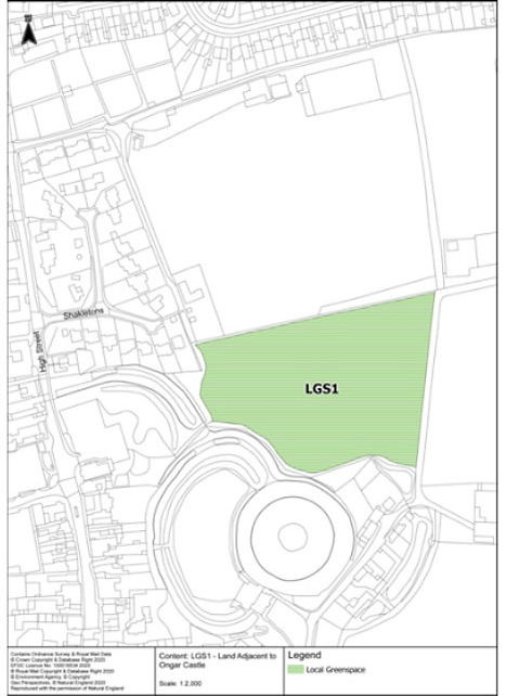
LGS1. Land adjacent to Ongar Castle (Castle Farm field and public footpath)
This level grassy site covering 1.94 hectares links the Pleasance Gardens adjacent to Ongar High Street with the 6.78 hectares of the Love Lane Jubilee Park. This is in the centre of the community within a short walk for residents and popular with walkers and dog walkers. The large field (cut annually for hay) with mature trees along its boundaries is in the tranquil setting of the Ancient Monument, with far reaching views to the east over the Roding river valley. A well-used footpath runs adjacent to the moat of Ongar Castle and leads the visitors towards the expansive views across the valley of the River Roding to High Ongar and southeast to the Brentwood Telecommunications Mast. A fine old horse chestnut tree near the Scout Hut is one of the 50 Favourite Trees of the District.

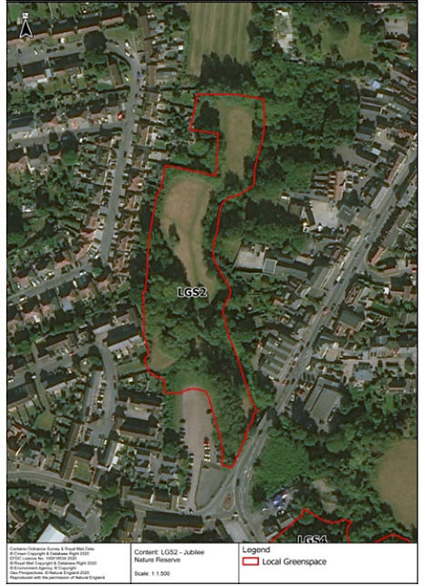
LGS2. Jubilee Nature Reserve, otherwise known as Cripsey Brook Nature Reserve.
Lying to the south West of Chipping Ongar with boundary of the Cripsey Brook and easily accessible for the community, there is increasing establishment of habitats for a number of different birds, small mammals and other river wildlife as identified in local, district and countywide records. Some are protected or declining species. Ongar Cripsey Brook Jubilee Nature Reserve (SO5) was designated as a Local Nature Reserve in 2007. Protected as a Fields in Trust site since 2015, its 0.82 hectares lies within the flood plain of the Cripsey Brook. A row of tall poplars lines the footpath linking Rodney Road with the High Street and the small flowery meadow alongside the Brook allows free access for walkers to spot various insects and possibly catch the occasional glimpse of a passing kingfisher. Badgers trundle through here after dark and bats swoop between the willows in search of food.

LGS3. Land East of Cripsey between Bansons Lane and Victoria Rd.
This scrubland between the Cripsey and Chipping Ongar High Street was a well-used network of footpaths, but recently partly cut-off by new development off Chipping Ongar High Street. It offers a natural Buffer to the open countryside and is tranquil. Originally called Long Meadow in the Chipping Ongar Tithe Award of 1838, this green open space is just over 0.8 Hectares of former meadowland. Today this area is covered with developing Hawthorn scrub with rank grasses, nettles and large amounts of Hemlock. Willows grow alongside the Brook. Some management would be required to prepare a useable footpath/shared cycle route in order to bypass a section of the High Road and link to become part of a green corridor round Chipping Ongar and the west of Shelley [109]


LGS4. Land between Longfields, Coopers Hill and farmland. Longfields
This site covers 0.39 Hectares and has been planted up with a mixture of deciduous trees set in grass planted up with a variety of spring bulbs. It is overlooked by the houses to east, south and west. Its northern boundary is the well vegetated corridor of the Cripsey Brook beyond which there is farmland. A welcome area near the main road filled with spring bulbs and trees, but big enough to confirm Chipping Ongar’s open character is of a rural, not urban nature. It provides a gap in the residential street with views over pastures either side of the Crispey and footpaths over the fields.


-
The following spaces are designated as Local Green Space:
-
LGS1 Land adjacent to Ongar Castle
-
LGS2 Jubilee Nature Reserve otherwise known as Cripsey Brook Nature Reserve
-
LGS3 land East of Cripsey between Bansons Lane and Victoria Rd
-
LGS4 Land between Longfields, Coopers Hill and farmland
The location and extent of the four green spaces are shown on Maps LGS1, LGS2, LGS3 and LGS4 in the Plan
-
-
Development in the Local Green Spaces will be consistent with the national policy for Green Belts.
POLICY ONG-CT1: LONG GREEN SPACE
INTERPRETATION OF ONG-CT1
The policy designated Local Green Space and sets out how impacts of development should be considered. This includes impacts of development near to or adjacent to the space.
National policy makes clear that Local Green Space has similar protection to Green Belts (para 101). However, it should be noted that the purpose of Local Green Space is about recognising and protecting special community value, rather than the five purposes for Green Belt.
RATIONALE: COMMUNITY, CULTURAL, LEISURE AND SPORTS FACILITIES
Community, leisure, and cultural facilities are important for the social and economic welfare of Ongar Civil Parish community and also serve its surrounding rural settlements. Ongar is a lively active community supported by sports, cultural and social clubs for a variety of different interests and age groups. Facilities and amenities include Ongar Leisure centre and swimming pool, Zinc Arts Centre, Budworth Hall, several Church Halls and Ongar Public Library. These are mainly located in the proximity of Chipping Ongar town centre. Nearby is Ongar Sports Community Club at Jubilee Park and the various Open Spaces are located throughout the Civil Parish and at ‘edge of settlement’.
Ongar’s thriving sporting community has been ”a major part of Ongar life going back to the 19th century” [110] . Today there are facilities for football, rugby, netball, badminton, tennis, cricket, squash, petanque and croquet, although it lost its facilities for its hockey and bowls clubs some time ago. Although requiring refurbishment, the Leisure Centre, with 4 indoor courts, and fitness and gym facilities and a swimming pool is well-supported [111]. Land was originally bequeathed, and the facility provided for the community in the late 1960s. The pool also enables the local primary schools to comply with the National Curriculum and is also valued by under 18s and older residents, many of whom do not have a car [112].
It is important for continued community well- being that sufficient new or enhanced sports and leisure facilities are provided in the civil parish at the same time as new housing. In addition, open space and playing areas for youngsters need to be provided with developments over 10 dwellings [113] such as Local Equipped Area for Play (LEAP) but provision for larger Neighbourhood Equipped Area for Play . (NEAP) and areas for older youngsters and adults, could be more central to support the regeneration of community hub in the town centre. Provision of LEAPs and NEAPs is covered in EFDC Local Plan policies and arrangements for developer contribution. Open Spaces are dealt with more fully in section 8.5 Infrastructure Priorities for Ongar and section 7.5 Natural Environment and 8.2 Local Greenspace.
An audit of existing sports related provision was carried out by 4Global for EFDC in 2016 and is included in their reports. [114] An update was carried out by ONPCG in 2018/9 [115], which reflects recent loss of outdoor courts and pitches at Ongar Leisure centre and that the Jubilee Park sports provision is no longer run by Ongar Town Council but a Trust.
Conclusions of 4 Global were that further playing pitches would be required [116] (football and rugby) within the 2011-2033 period including all-weather pitches and, that the provision of built facilities [117] (health and fitness) in Ongar needed to be ‘protected’ [paragraph 9.4. 2] and ‘enhanced’ [paragraph 9.4.3]. Provision of a future Multi Use Games Area (MUGA) court would provide facilities for important local sports such as netball which are currently unable to train or host competitions due to inadequate facilities. Netball court provision is not assessed in 4 Global Plying Pitch Strategy. (see also ONG-CT4 Infrastructure Priorities)
Some local community halls provide facilities for a limited number of fitness and sports and are also limited by the number of people that can be accommodated at a single meeting. Any loss of such facilities would be detrimental to the community cohesiveness. [118]
NPPF paragraph 93 and paragraph 98 ensure that planning policies plan positively for the provision of the social, recreational and cultural facilities and services that the community needs, based on assessments of the need and opportunities for new provision.
Epping Forest District Local Plan 1998 and Alterations 2006 (published 2008) – Policy WLP8.23 protects Open Space, community sport and recreation facilities from development. EFDC Local Plan 2011-2033 Policy D 4 Community, Leisure and Cultural Facilities offers similar protection to facilities valued by the community. Epping Forest District Council compiled the Open Space, Sports Facility and Playing Pitch Strategy in 2012 (EB700) and commissioned 4 Global to update this in 2017. Citing the Essex Sports Facilities Strategy 2007-2020’, EB713 recommends (among other things) investment to maintain current levels of provision of facilities and goes further with enhancement recommendations as previously stated. EB1101B Infrastructure Delivery Schedule 2017 supports some general recommendations with some potential funding to come from s106 contributions.
EFDC’s Built Facilities Strategy (4 Global) 2018 v 7.0 (EB713) considers indoor swimming pools, sports halls (of a minimum size) and health and fitness suites. This concluded that Ongar’s swimming pool is at ‘the end of life and requires modernisation or replacement; the sports hall has high unmet demand and requires refurbishment; and the Health and Fitness provision is not only ‘vital’ but need modernising and improving. Ongar Leisure Centre serves a wide rural population, including outside EFDC boundaries. Any replacement’ but must remain in the civil parish of Ongar. Recent petitions indicated the strength of feeling from local residents.
It is Ongar Neighbourhood Plan’s aim that any new community facilities should be centrally located within Ongar Civil Parish and easily accessed from the Chipping Ongar town centre, (except for smaller children’s playing areas – Local Areas for Play (LAP) and Locally Equipped Areas for Play (LEAP) which would be located within or in close proximity of development sites). This will ensure that there is an effective community hub, especially as the retail element of the town centre has declined.
The responses in the Residents Survey [119] reveal that over 70% consider additional outdoor and indoor sports pitches and fitness facilities are needed.
Play areas and equipment are valued by the community


POLICY ONG-CT2: COMMUNITY, CULTURAL, LEISURE AND SPORTS FACILITIES
-
Development involving the loss of facilities will be supported only where new or better facilities are provided in close proximity and within Ongar civil parish or where there is evidence that the facility is no longer required to meet local need.
-
Particular regard should be made to impacts on the following key facilities: The playing pitches and courts, Ongar Leisure Centre, Ongar Library and youth facilities.
INTERPRETATION OF ONG-CT2
This Policy applies to all types of community, cultural, leisure and sports facilities.
In the case of facilities in and around the defined Small District Centre, close proximity would mean within or immediately adjacent to that defined boundary. Elsewhere within the neighbourhood area, in close proximity means within the Ongar Neighbourhood Area (i.e., within Ongar Civil Parish boundaries) and preferably within walking distance of the original facility or amenity and the centre of Chipping Ongar (which is the Budworth Hall).
The policy seeks to maintain the level of community facilities and amenities in the area, including those in and around the centre. Provision of new facilities is supported by Policy ONG-RR1. Consideration will be requested to designate the named facilities as Assets of Community Value
RATIONALE: TRANSPORT AND MOVEMENT
The National Design Guide 2021 and the National Model Design Code 2021 states that well- designed places will have accessible forms of transport, safe walking and cycling for local journeys, sufficient car parking and cycle provision that is not intrusive or dominates the street scene and that designs enable easy access for refuse collection or emergency services.
Various reports for EFDC and ONPCG [120] as well as EFDC Local Plan 2011-2033 paragraph 3.87 recognise the difficulties in providing viable solutions for public transport and cycleways in more rural areas such as Ongar. However, new proposed housing developments can provide a connected network of streets with walking and cycling routes and ensure that there is sufficient high quality car parking provision and cycle storage, well integrated and which does not dominate the local environment. [121]
Due to the relatively isolated rural location of Ongar, with little local employment [122] and inadequate public transport [123], Ongar residents have a high dependence on cars. 49.2% of Ongar households own or have access to two or more vehicles [124] which is nearly 20% higher than the average for England. More than half of Ongar’s workers commute outside the area including to London [125], with over two thirds of all workers’ main journey being by car [126].
Existing parking issues in Ongar [127] relate to on street and overspill parking in some housing estates. Insufficient space for the growing demand is also an issue at Ongar Health Centre, and at times Chipping Ongar Town Centre, and at Recreation and Leisure facilities. Ongar serves a large rural hinterland, providing an important function to a large geographic area.
Local roads are congested as recognised by EFDC [128]. Ongar’s road network includes very busy PR1 routes, which also cause problems of movement within the parish itself [129]. Ongar itself has a small population. The extent of through traffic is confirmed by the January 2017 ECC traffic survey daily traffic flow of over 17,500 through the High Street, many being HGVs.
Research conducted by Epping Forest District Council and others [130] have identified that the key transport and movement issues facing Ongar are:- limited public transport accessibility, a high reliance on cars, insufficient parking provision in the town, major problems in the high street caused by high levels of through traffic and particularly HGVS, and poor facilities and connectivity for pedestrians and cyclists.
Government policy on transport and parking acknowledges the need for sufficient parking provision [131]. ECC has adopted a minimum parking space requirement, which is also used by EFDC [132] Context appraisal and local character of the parish of Ongar confirms that Ongar’s location is not appropriate for lower numbers of car park spaces. ECC has also said :
“The Highway Authority does not consider Ongar to be an accessible location in terms of good access to other modes of sustainable travel and consequently a reduction in the parking provision would not be supported at this location”. [133]
National Design Guide (2021) para 67 requires “strategies for parking that support the overall quality of the place” , The National Model Design Code 2021 and NPPF 2021 provide more detail, as does Essex Design Guide and Ongar Design Guide.
All Ongar developments will be expected to justify the residential parking spaces provision, fully considering residents’ need for travel beyond Ongar, in compliance with Essex Parking Standards 2009 as appropriate for the rural community of Ongar. Design must ensure that the car does not dominate the street scene, by providing sufficient off-street car parking in new developments, located where cars can be seen by owners and neighbours. Refuse collections and emergency vehicles must also have assurance of unobstructed access.
Larger homes should provide more than 2 car parking spaces [134] in accordance with the expected occupancy, to prevent overspill car parking onto the street or any of Ongar’s other roads, which would exacerbate existing parking issues.
Car parking provision also requires conveniently placed electric charging points for each new home or parking area (see Section 7.5 Sustainable Design and policy ONG-ED4). Wherever possible, designs should be adaptable [135], and allow for features such as new charging technologies. In order to encourage other modes of transport, all new dwellings are expected to provide conveniently placed secure cycle storage.
Due to existing capacities, road junction improvements will be required to accommodate increased traffic, especially from the larger developments such as at A414 by the 4 Wantz roundabout in the north and the junction of Chipping Ongar High St, The Borough (leading to Greensted Rd) and Coopers Hill in the south. This should include repositioning bus stops [136].
The existing built up area in Ongar includes pedestrian short cuts from estates to community facilities, but many routes by necessity have to follow along Chipping Ongar High Street. This has stretches of very narrow footways in the historic area, making it unsafe to encourage cycling in the High Street itself. However, there is the opportunity for new estates (including ONG R1-8 sites allocated in EFDC Local Plan) sited at the edge of settlement to provide additional pedestrian and cycle friendly short cuts linking into existing routes, including PROWS to encourage walking or cycling for local journeys.
Access roads into allocated sites ONG-R1-8 in EFDC Local Plan are directly onto main roads, or in the case of ONG-R5 a narrow country lane near a primary school. To further support pedestrians, safe crossings and pedestrian crossings should be provided on routes to enable safe access to link to bus stops, school routes, shops and other community amenities.
Policies for regeneration of the historic Chipping Ongar town centre is in Section 6.3, Policy RR2 and where issues are outside the scope of a planning policy, Actions are in the Appendix to Ongar Neighbourhood Plan. Heavy through traffic detracts from High Street’s ambience. A by-pass was proposed several times over the last 70 years round Shelley and the east of Chipping Ongar and Marden Ash. There are no approved plans for such in the lifetime of the EFDC Local Plan 2011-2033. Ongar community continues to work with Essex Highways and EFDC to resolve the existing congestion in the High Street and to exclude the heaviest and largest HGVs, which are also causing undue pollution and damage.
As the local economy improves, new homes built and visitors increase, additional parking provision is likely to be needed in Ongar Town Centre, as well as by the Health Centre and sports and leisure facilities. See also Section 6.3 and Policy RR2. With only 3 small car parks in Chipping Ongar and many first floors of shops being converted into residential, there is a need for another long stay carpark for residents, employees of local businesses.
Any new employment or industrial site in or near Ongar which creates traffic movement, including HGVs, which will adversely impact on the attractiveness and congestion in the historic centre will be unacceptable, including those creating significant increase in air and noise pollution of all kinds. Developers will be expected to provide a Transport Statement to mitigate against any impact and include monitoring and enforcing methods.
POLICY ONG-CT3: TRANSPORT AND MOVEMENT
-
All development must include a balanced range of transport options. This includes
-
Ensuring sites are served by adequate roads and footways with particular regard to traffic capacity and pedestrian safety
-
Providing sufficient off-street parking facilities to support the higher levels of car ownership in Ongar as a primarily rural area, including multiple car households, by using Essex Parking Standards 2009 or successor standards;
-
Providing parking through a mix of covered space, garage space and driveways;
-
Providing secure and screened cycle storage in all development, including for each new house;
-
Taking opportunities to link to surrounding footpaths (PROWs);
-
Providing good pedestrian permeability and the creation of safe and convenient pedestrian routes within the site, including for people with limited mobility or using mobility scooters;
-
Providing safe crossing facilities where necessary to link to nearby shops, bus stops, schools and other facilities;
-
Providing convenient and direct access charging points for electric vehicles.
-
-
When considering employment development likely to generate movements by heavy goods vehicles, particular attention must be paid to the impacts of such vehicle movements on the town centre and its historic environment in terms of noise, disturbance, pollution, air quality, congestion and attractiveness to users of the High Street.
-
Employment development should include facilities for secure storage of cycles. For business parking areas, conveniently located charging points for electrical vehicles should be provided.
INTERPRETATION OF ONG-CT3
The policy should be applied according to the scale of development. Clearly, the parts of the policy relating to layout and permeability apply where new layout is being provided. Other parts of the policy would apply to all scales of development, from one dwelling upwards, for example the need for secure storage space for cycles.
Due to the lack of local employment in Ongar Civil Parish, poor commuter public transport connections and the resultant reliance on car transport, there is a requirement to provide sufficient off-street car parking space in compliance with Essex Parking Standards 2009. The Essex Design Guide, National Design Guide 2021, National Model Design Code 2021, and Secured by Design provide further guidance, in applying the policy. Ongar Design Guide provides further clarification and examples of concerns.
‘Convenient charging points’ means adjacent to private driveway or parking space. See also requirements in the EFDC Local Plan 2019-2133
The policy should be applied to larger extensions where it would create an additional need for off street parking.
See also:
Section 7.5 Sustainable Design Section and Policy
Section 6.3 Chipping Ongar High Street and Policy relating to providing sufficient parking, including for visitors town centre
Section 8.6 Walking and cycling routes
Appendix of Ongar Neighbourhood Plan- Projects and Actions. This proposes solutions for reducing congestion and HGVs in Chipping Ongar High Street and accommodating car parking for an increased Visitor economy, which is outside the remit of Ongar Neighbourhood Plan Policies.
RATIONALE: INFRASTRUCTURE PRIORITIES
A variety of Infrastructure requirements for Ongar have been itemised to support new housing development in EFDC Local Plan 2011-2033. These cover utilities, highways, education, health, open space, community facilities and sports and leisure [137] and are supported by reports and evidence such as 4 Global reports etc. Many are categorised as critical or essential, whilst others are desirable. Where there is likely to be a choice of actual provision, or a choice of location, such as where to put a pre-school, Ongar Neighbourhood Plan has prioritised those that are likely to require contributions from more than one Developer, including via s 106 contributions, as the most beneficial overall. These priorities are supported by surveys conducted by ONPCG in the community [138]
NPPF Paragraph 34 deals with infrastructure contributions requiring Plans to set out the contributions expected from each development.
EFDC Playing pitch strategy (4 Global) 2018 v 7.0 (EB714) covers football, cricket, rugby and hockey in accordance with Sport England recognised assessments. The findings of the 4 Global report concludes that there will be a need for more football and rugby pitches. This echoes Ongar Sports Clubs call for the same and the Residents Survey. Consideration for an artificial grass pitch (AGP) has been called for, partly due to the heavy clay soils in Ongar which are subject to waterlogging during the winter months.
Sports provision played on courts, such netball, tennis and basketball, were not assessed by EFDC. There are tennis courts at Ongar Sports Club in Jubilee Park, but several have been lost at Ongar Leisure Centre as have netball courts. Netball, in particular, has strong support in Ongar but current facilities are not suitable for competition or year-round use. A MUGA (Multi Use Games Area)- being a pitch or court surface which can accommodate various sports would serve the community well.
EFDC Local Plan 2011-2033 Policy DM6 deals with designated and undesignated Open Spaces: It requires provision of open space in accordance with the guidance contained within the Infrastructure Delivery Plan and Open Space Strategy. Nationally adopted space standards will be used as a starting point for provision’. This includes play areas (LAPS, LEAPS and NEAPS). Ongar, despite surrounded by countryside, will have a need for more accessible ‘Open Space’ and a ‘town park’, which should be located centrally to benefit the whole community. Proposals have also been identified in Actions and Projects Appendix.
Another major requirement is a new pre-school (identified in EB 1101B EFDC Infrastructure Delivery Programme for Ongar). This should be located in or close to Chipping Ongar town centre . This would be equidistant to the two primary schools and have the added bonus of bringing more people into the town centre.
Where there is a choice, Ongar’s preferences are for contributions towards amenities and facilities that would benefit the whole area rather than only a small estate.
POLICY ONG-CT4: INFRASTRUCTURE PRIORITIES
Ongar Town Council’s priorities for the provision of infrastructure through use of Section 106 or similar developer contributions are:
-
Additional sports pitches and courts including artificial grass pitches and MUGA courts;
-
A new town park in close proximity of Chipping Ongar town centre and Ongar Castle;
-
Pre-school provision in close proximity of Chipping Ongar town centre.
INTERPRETATION OF ONG-CT4
The policy is intended to guide decisions by the Local Planning Authority with regard to use of financial contributions through Section 106 or subsequent developer contributions, whilst acknowledging that such matters relating to improvements to highways, education and utilities will take precedence. This may include land acquisition costs. EFDC’s up to date Infrastructure Delivery Programme for Ongar will be expected to be used in conjunction with this Policy.
In accordance with the government’s policies for greater decision making at local community level, the residents survey has confirmed the priorities in ONG-CT4. Better outcomes are likely to be achieved if the design process for new infrastructure involves meaningful engagement with local stakeholders and community groups in Ongar at pre application stage. Ongar Town Council will therefore be expected to be involved in decision making for s106 contributions ( or equivalent) from developers.
RATIONAL: FOOTPATH AND CYCLE ROUTES
There are a number of footpaths linking parts of the civil parish with nearby settlements, and several long-distance footpaths passing through Chipping Ongar. In addition, there are some short cuts or alleyways through established housing estates to Chipping Ongar town centre.
Roads through Ongar are busy, and many footways (pavements) are narrow. Therefore, to encourage more local journeys to be on foot or cycle, a more ‘joined up’ network of footpaths and cycle routes is needed. Furthermore, new development should ensure access onto existing footpaths, such as in the West Ongar Concept site R1 and R2, and where possible expand these routes.
There is a need for safe pedestrian crossings or refuge places along children’s walking routes to school [139]. Pedestrian and cyclist shortcuts and improvements to paths within and around Ongar must be considered in the layout of new housing sites in order to encourage local journeys by foot or cycle.
Supporting a better network of footpaths and cycling paths round Chipping Ongar and Shelley to encourage non-car local journeys could also open up the opportunity of providing an interesting selection of walks for visitors around the historic town. This could involve coordinating activities and signposting for the Heritage Railway, Greensted Church, long-distance footpaths of The Essex Way, St Peter’s Way and Three Forests Way and other attractions, interactive Town trails, a Tourist Information Point and the use of new technology for Wi-fi and 5G [140]. This could open up a new market for the local economy.
The reopening up of footpaths between the Cripsey Brook and the town from Bansons Lane to the Heritage Railway has been proposed. [141] It would enable school children to avoid the busy High Street and encourage walking or cycling as a short cut.
See also Policy ONG-CT1 Local Greens Space LGS3 and ONP Projects and Actions to link round the west south and east of Chipping Ongar alongside the two rivers, including the Nature Reserve to form Green Corridors [142].
This route would also link to the footpath from Bansons Lane to Millbank Avenue and new proposed estate in Greensted Road ONG-R5 (EFDC Local Plan).
Where new or existing footpaths go through built up areas, including alleyway shortcuts, urban design principles should include ensuring personal safety by avoiding enclosing footpaths between high enclosures with no natural surveillance. The use of Secured by Design Homes 2019 (official police security initiative) is recommended, as also detailed in National Design Guide and National Model Design Code 2021 [143]
The NPPF and EFDC have Planning Policies and frameworks to support walking and cycling routes for healthy lifestyles and to encourage less reliance on motor vehicles. This includes: Paragraph 85 of Section 6 and Paragraph 92 of Section 8 of the NPPF 2021 and EFDC Local Plan 2011-2033 Policy T1 Sustainable Transport Choices. Footpaths and cycle routes should be safe, pleasant and convenient with practical links onto adjoining public rights of way and cycleway networks.
In Ongar such a network would enable better connectivity within the civil parish, as well as better off road links to neighbouring villages. However, some may also need improved maintenance of surfaces and the reduction of overhanging vegetation on footpaths -PROWS and alleyways- to enable all year round use.
See also ONP Projects and Actions which proposes a new permissive footpath along the banks of the river Roding, linking to Chipping Ongar town centre through existing PROWS. Opportunities to boost the local economy could follow.

Properly signed and well-designed paths can provide good car free access to the town centre from new and existing developments thus enhancing sustainability for all


POLICY ONG-CT5: FOOTPATHS AND CYCLE ROUTE
-
New development should protect and wherever possible take every opportunity to enhance the accessibility, safety and amenity of existing footpaths and other public rights of way. This includes:
-
Not encroaching onto footpath routes;
-
Avoiding flanking footpaths with high enclosures or blank walls;
-
Retaining an open or partially open setting to footpaths wherever possible and it would be safe to do so;
-
Ensuring that the layout within development provides access points to adjacent footpaths wherever possible and it would be safe to do so;
-
Providing low-level landscaping adjacent to footpaths wherever possible and it would be safe to do so.
-
-
Sufficient land in the area indicated on map ONG-CT5 is safeguarded to allow the provision of a new cycleway and footpath.
-
Access from new developments to new footpaths or PROWs will be encouraged, especially if they link into existing networks or semi natural green space.
INTERPRETATION OF ONG-CT5
The policy requires careful consideration of impacts of all development in Ongar on footpaths (footways adjacent to roads and also PROWs144). Design and access statements provide an opportunity for developers to explain how compliance with the policy has been achieved, and enables new footpaths to be beneficial for Visitor economy and reducing dependency of cars for local journeys.
See also Ongar Neighbourhood Plan Appendix Projects and Actions
106 NPPF paragraph 102. Ministry of Housing and Local Government. Revised NPPF July 2021 Government Publications.
107 Ongar Local Green Space Assessment and Proposals 2020 see evidence file
108 Local Areas for Play (LAP), Locally Equipped Areas for Play (LEAPS), Neighbourhood Equipped Areas for Play (NEAPS)
109 See Ongar Neighbourhood Plan Projects and Actions Appendix
110 Ongar Sports Club states in its 2019 Plans and Aspirations for the future “Sport has been a major part of Ongar life going back to the 19th century. Ongar cricket club was formed in 1845 and is one of the oldest clubs in the county. Ongar Football Club was one of the founding clubs of the Essex Olympian League over 120 years ago. Ongar Tennis Club was formed in the 1950’s. So, sport has a long tradition in the town.”
111 Resident Survey 2018 questions 6.3.1 and 6.3.2 suggest many would not travel if Ongar leisure centre closed and relocated outside the parish. On average in 2016-2017 there were around 22,000 visits a month
112 see Residents Survey 2018 and Youth Survey in evidence files and ONS statistics-14.2% households in 2011 had no access to a car
113 Fields In Trust guidelines
114 EB703 EFDC Open Space strategy 2017 (4Global); EB 714 EFDC Playing Pitch Strategy 2018 v. 7.0 (4 Global); EB 713 EFDC Built Facility Strategy 2018 v.7.0 (4 Global) see EFDC Local Plan website Evidence Base
115 See evidence files for more information
116 EB 714 EFDC Playing Pitch Strategy 2018 v. 7.0 (4 Global) see EFDC Local Plan website Evidence Base 117 EB 713 EFDC Built Facility Strategy 2018 v.7.0 (4 Global) see EFDC Local Plan website Evidence Base 118 See Ongar Neighbourhood Plan Projects and Actions Appendix
119 Residents Survey 2018 see evidence file
120 Including ARUP Site Selection Report Town Proforma of Chipping Ongar 2016 EB801O Appendix C and ONPCG Residents Survey and Town Survey -see evidence files
121 See National Model Design Code parts M1 M2 & M3 and Essex Design Guide
122 Several major employment sites in Ongar including the May and Baker site at the Fyfield for housing
123 TfL also closed the Central line link in the mid-1990s, limiting public transport options further. Epping Ongar Railway is now a privately owned Historic railway and unlikely to be re-established as a commuter line
124 Residents Survey 2018 questions 4.2 and ONS 2011 census and ONS
125 car ownership, as shown in the Rural Community Survey for Ongar (Parish Action with Communities in Rural England (ACRE) Rural evidence project October 2013 – p35; Transport and connectivity: Access to private transport and in the last Census ONS statistics 2011 in RCCE and Navigus Reports see evidence files
126 ONS 2011 and Ongar State of The Parish Report (Navigus) see Evidence files
127 Residents Survey 2018 and Town Survey and Ongar Design Guide see Evidence files
128 EFDC Local Plan 2011-2033 Sustainable Transport Corridors paragraphs 3.82 and 3.84 in particular
129 The A414 dissects the parish between Chipping Ongar and Shelley, and Chipping Ongar High Street A128 is problematic for all users and residents and subject to further congestion when the M11 or M25 have issues.
130 EB801 O ARUP EFDC Site Selection Reports Appendix C Town Proforma- Chipping Ongar
131 Eric Pickles statement March 2015 https://questions-statements.parliament.uk/written- statements/detail/2015-03-25/HCWS488 and NPPF 2021; National Design Guide2021; National Model Design Code 2021
132 Local Plan 2011-2033 para 3.92 as rationale for Policy T2
133 Essex Highways in 2021, objected to 9 flats being built with lower than Essex Parking Standard at the south end of Ongar High Street for the above reason and of the consequences of overspill onto local roads and stated: “ The Parking Standards Design and Good Practice September 2009 recommends minimum parking provision levels for residential properties”… “The Highway Authority does not consider Ongar to be an accessible location in terms of good access to other modes of sustainable travel and consequently a reduction in the parking provision would not be supported at this location”. “
134 Essex Parking Standards 2009 stipulates 2 spaces for a 2 bed or larger house or flat and visitor space.
135 Essex Design Guide includes various design ideas for parking that does not dominate the street scene including undercroft and underdeck parking, which could be applied in some developments
136 There are several proposals locally to address this situation, improve pedestrian safety and provide additional long stay and coach parking in the south of the town
137 EB1101B Infrastructure Delivery Schedule EFDC Evidence Base https://www.efdclocalplan.org/local- plan/evidence-base/
138 See Residents Survey 2018 and other surveys in the Evidence files
139 See ONP Projects and Actions Appendix; and Risk Assessment for walking routes to Ongar schools including from proposed new development sites in Evidence files
140 See ONP Projects and Actions Appendix
141 See ONP Projects and Actions Appendix
142 See ONP Projects and Actions Appendix and map